 Texas : Safety by City
- Abilene
- Amarillo
- Austin
- Beaumont
- Brownsville
- Carrollton
- Corpus Christi
- Dallas
- Del Rio
- Dell City
- Denton
- El Paso
- Fort Davis
- Fort Worth
- Fredericksburg
- Frisco
- Garland
- Granbury
- Grand Prairie
- Gruene
- Harlingen
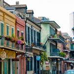
- Houston
- Irving
- Laredo
- Lewisville
- Llano
- Lubbock
- Luckenbach
- Marathon
- Marfa
- McAllen
- McKinney
- Mesquite
- Midland
- Nacogdoches
- New Braunfels
- Plano
- Port Aransas
- Richardson
- San Angelo
- San Antonio
- Schulenburg
- Sherman
- Smithville
- South Padre Island
- Tyler
- Waco
- Waxahachie
- Weslaco
- Wichita Falls
- Wimberley
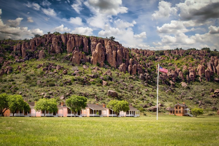
Fort Davis, Texas, is the highest town (5,050′) in the state and is often compared to a Colorado mountain town more than a West Texas landscape.
That underrated appeal extends to the two national parks nearby – the Guadalupe Mountains and Big Bend – with Fort Davis a nice central point between the two.
As a bonus, some of the most pristine night skies in the United States are found here, with stargazing that reaches epic proportions.
The fort that became the name of this town holds historical significance as a former military outpost established in 1854 to protect travelers along the San Antonio-El Paso Road.
Named after then-Secretary of War Jefferson Davis, it played a vital role in guarding the region during the Indian Wars and the Civil War.
The fort is now a well-preserved site within the Fort Davis National Historic Site, which falls under National Park Service oversight.
TRAVEL TIP: The fact that three NPS sites are in this region makes America the Beautiful Interagency Pass a great idea for potentially saving money.
The pass is $80 for a full year, with access to 2,000+ public lands.
One pass covers up to four people over the age of 16 (15 and under are free).
If you’re traveling with a group of four or more, you’ll save money with the annual pass.
Warnings & Dangers in Fort Davis

OVERALL RISK: LOW
There's a low risk in Fort Davis and an abundance of outdoor and historic things to do. The town breaks the mold of what you'd expect in West Texas and offers some of the coolest summer temperatures statewide.

TRANSPORT & TAXIS RISK: LOW
You'll need a car to get to Fort Davis. There's no public transportation or buses that serve this region. The risk is low, but please research the proper emergency kit to store in your car in case of a breakdown.

PICKPOCKETS RISK: LOW
Just one pickpocket has been reported in the past 10 years, and that's on top of an incredibly low theft rate. Don't let your guard down, and keep practicing smart safety steps, like limiting what you carry to the bare essentials, but this is one of the safer places in Texas when it comes to theft.

NATURAL DISASTERS RISK: MEDIUM
Fort Davis faces several natural disaster risks, so treat it as a medium risk. The area is susceptible to wildfires. Flash floods are also a concern, particularly in low-lying areas, during heavy rainfall events. Additionally, occasional severe storms, including hail and high winds, can occur. You need to stay aware of the weather before you go into the wilderness.

MUGGING RISK: LOW
No robberies have been reported in the past decade in Jeff Davis County, giving this a low risk. While that's comforting, you should never let your guard down when visiting a new place.

TERRORISM RISK: LOW
The risk is low for a terror attack, but given how close Fort Davis is to the border, be on the lookout for illegal immigrants or possible drug runs on the highways. This is a place where you should never stop to help someone on the side of the road or pick up strangers.

SCAMS RISK: LOW
Check local law enforcement social media sites for the latest scams. The local Better Business Bureau office and the state Attorney General’s office will have common scam tactics and protection advice. Don't give money to panhandlers or buy items from people on the side of the road. Sometimes, people illegally cross the border and try to sell items to tourists - the U.S. government doesn't allow this, and you can get in trouble for supporting this activity.

WOMEN TRAVELERS RISK: LOW
Women face the same low risk, but it's important to know wilderness safety and how to handle a confrontation with illegals in the wilderness. The sheriff's office and Border Patrol websites have plenty of safety tips. Don't go hiking alone here.

TAP WATER RISK: LOW
The U.S. has strict standards for tap water per the Safe Water Drinking Act. I cannot find the latest report for Fort Davis Water Supply Corporation, and the only thing I can find was a violation issue in 2021 and a property dispute that was settled in 2024. It would be wise to ask your hotel for proof of water quality testing. You might want to bring a case of water for drinking. I would also avoid the water in Toyah, as that town has an ongoing issue of water that isn't safe to consume.
Safest Places to Visit in Fort Davis
Fort Davis travel planning resources include the local Chamber of Commerce, plus tourism guides for West Texas and the Big Bend area.
(The Big Bend area in Texas derives its name from the prominent bend in the Rio Grande River that forms a large, sweeping curve in the region.)
It’s worth noting that each small town or community in this region has distinct attractions, but Fort Davis stands out for its location in the mountains.
We talked earlier about the Fort Davis National Historic Site.
While the historical aspect is cool enough, this is one site that also includes hiking trails.
Better yet?
The trails are short and lead to sweet, sweeping views of the region.
However, some are rather challenging, so check the hike ranking for each one.
Hospital Canyon Trail is one of the more advanced routes.
Davis Mountains State Park is the closest mountain to Fort Davis, and you can walk or bike the Skyline Drive Trail to and from the fort.
Limpia Canyon Primitive Area offers horseback riding trails with a remote campsite.
The park has a bird blind open to the public where you can watch birding activity as long as you’d like.
More outdoor adventures can be found at the Chihuahuan Desert Nature Center and Botanical Garden.
At an elevation of 5,100 feet, you can explore more hiking trails mixed with grasslands and igneous rocks jutting from the surface.
The center also has a cactus garden, a bird blind, a mining exhibit, and a geological timeline of the rocks across this mountainous region.
The McDonald Observatory in Fort Davis, Texas, is a world-renowned astronomical research facility and educational center.
Perched atop Mount Locke and Mount Fowlkes, it offers stunning views of the night sky through its powerful telescopes.
Visitors can enjoy guided tours, star parties, and educational programs year-round.
One of the unique things to see in this region is between Marfa and Alpine.
They are known as the Marfa Lights, but nobody is sure where the lights come from.
The phenomenon is big enough to warrant its own festival, but the Marfa Lights can be seen year-round.
Finally, it looks like, as of March 2024, Fort Davis now has an Old Sheriff’s Museum and Research Center open to the public.
The goal is to showcase the law enforcement history in West Texas.
Places to Avoid in Fort Davis
Crime isn’t a concern here, so don’t worry about bad parts of town.
The biggest thing to avoid is going into the wilderness unprepared.
You’ll need at least a gallon of water per person, sunscreen, a paper map, a first aid kit, and salty snacks to replace electrolytes.
Always tell someone where you are going and when you plan to be back.
While the wildlife here is interesting, what with javelinas and bears, you should never get closer than 25 yards to the wildlife.
Bring bear spray, but only use it if an attack is imminent.
Avoid reaching your hand onto a rock or under a piece of wood without looking first – scorpions, snakes and spiders like to hide in cool, dark places.
The Nature Conservancy oversees another section of the David Mountains separate from the state park.
Davis Mountain Preserve, about 25 miles north of Fort Davis, offers limited public access.
Here’s what you need to know:
- Madera Canyon Trail is open year-round.
- Access to Mount Baldy and Mount Livermore is available on specified weekends only – check the website for those dates.
- High-clearance vehicles are required to go past the conservation center.
Safety Tips for Traveling to Fort Davis
- Law enforcement in Fort Davis comes from the Jeff David County Sheriff’s Office. I want to point out that the Facebook page for the sheriff is @JDCSheriff, but it appears that it stopped being updated in 2022. You can also call (912) 375-6600 with specific safety information.
- Sign up for Reverse 911 calls to get information about severe weather, wildfires, or public safety hazards. You can’t afford to miss these important emergency messages.
- Bookmark the Inciweb website to keep an eye on wildfires burning in the region. It is also important to see if wildfire smoke from far away fires could impact the air quality. An app like IQ Air is great for checking the air quality, too.
- Check the fire danger each day that you’re visiting. There are signs throughout the mountains showing a fire danger risk. However, beyond the risk, some restrictions come into play at certain risk levels. For example, a campfire ban might be in place. Keep an eye on the local fire department’s Facebook page @FortDavisFireDepartment.
- West Texas is known for fierce winds from February through May. It’s not uncommon for 30-40 mile per hour sustained winds to blow for hours at a time. This can impact hikes through valleys and on ridgelines. Some people have even reported winds too harsh to even stay upright on a bike.
- Even with winds that are more annoying than dangerous, it’s smart to grab leftover COVID masks or a bandanna to wrap around your mouth and nose to avoid dust getting in. I bring goggles when I’m hiking in windy areas, no matter how silly I look.
- Before you even think about a trip to Mexico, check the U.S. State Department travel warnings. The closest border town is Ojinawa in the state of Chihuahua. As of May 2023, the travel warning there reads, in part, “Battles for territory between criminal groups have resulted in violent crime in areas frequented by U.S. citizens and U.S. government employees, including restaurants and malls during daylight hours. Bystanders have been injured or killed in shooting incidents.” One of the safest border crossings is the town of Bouqillas in Big Bend National Park.
- Anglers need a fishing license from the Texas Parks and Wildlife Department. The license must be carried at all times while you’re fishing. You can also look at the hunting license options if that interests you. One great number to save in your phone is 800-792-GAME – that’s the number to report illegal poaching of wildlife.
- Between the elevation and the low humidity, those not used to either condition could be prone to nosebleeds. Put some Vaseline in your nostrils each day to keep them from drying out.
- Use the Drive Texas website and app to check for road conditions. You can find real-time traffic, road construction, weather reports, and live cameras on the site.
So... How Safe Is Fort Davis Really?
Since Fort Davis gets law enforcement from the county, I would normally tell you that I can’t give an accurate depiction of crime in a city due to the expanse of coverage.
However, this is a remote county of 1,900 people and 1,000 of those live in Fort Davis.
It also doesn’t make sense to share the crime rates here, as rates are determined by number of crimes vs the population.
It wouldn’t account for the thousands of people who drive through this town each year.
That said, the crime rate is still 87% lower than the national average.
Going back to 2015, Fort Davis hasn’t seen more than five violent crimes in a year.
In the past five years, just one crime has involved a stranger.
Even theft is low, with only one year in the past decade reaching seven thefts.
Only 18 thefts have been reported in the past five years.
How Does Fort Davis Compare?
| City | Safety Index |
|---|---|
| 80 | |
| 83 | |
| 74 | |
| 72 | |
| 85 | |
| 87 | |
| 85 | |
| 84 | |
| 83 | |
| 77 | |
| 67 | |
| 85 |
Useful Information

Visas
All international visitors need either a visa or a visa waiver. Start the process using the Visa Wizard module on the U.S. State Department website. You’ll quickly find out which one you need. Also, keep in mind that your passport must be valid for at least six months after our trip, or you’ll need to apply for a new one. Don't assume the regulations for going into Mexico and back into the U.S. are the same. Check the rules on the Border Patrol website.

Currency
Only the U.S. Dollar (USD) is accepted in the United States. International airports usually have a currency exchange desk on site, while regional airports won’t. Your home bank offers the lowest fees. For those using credit cards, check to see if there’s a foreign transaction fee before you start racking up charges. Don't wait until you're in the small town of Fort Davis to get cash.

Weather
West Texas is known for its extreme heat, but Fort Davis gets a bit of a reprieve thanks to the elevation. Winter will bring wide swings from day to night, with highs in the 60s and lows at or below freezing (all temps F). Summers get into the high 80s and 90s, with lows in the 60s. Triple-digit temperatures can happen, too. The lower elevations will be at triple digital for much of the summer during daytime highs.

Airports
The largest airport in West Texas is El Paso International Airport, which is about three hours from Fort Davis. Midland International Air & Space Port is about two and a half hours away. I wouldn't even think about San Antonio or the Dallas/Fort Worth Metroplex, as those are at least 5-7 hours by car.

Travel Insurance
Travel insurance goes into effect as soon as you purchase it. Comprehensive insurance offers the best protection and peace of mind.
Fort Davis Weather Averages (Temperatures)
Average High/Low Temperature
| Temperature / Month | Jan | Feb | Mar | Apr | May | Jun | Jul | Aug | Sep | Oct | Nov | Dec |
|---|---|---|---|---|---|---|---|---|---|---|---|---|
| High °C |
16 | 19 | 22 | 26 | 30 | 33 | 32 | 31 | 29 | 26 | 20 | 17 |
| Low °C |
-2 | 1 | 3 | 7 | 12 | 16 | 17 | 16 | 13 | 8 | 2 | -1 |
| High °F |
61 | 66 | 72 | 79 | 86 | 91 | 90 | 88 | 84 | 79 | 68 | 63 |
| Low °F |
28 | 34 | 37 | 45 | 54 | 61 | 63 | 61 | 55 | 46 | 36 | 30 |
Texas - Safety by City
| City | Safety Index |
|---|---|
| 67 | |
| 65 | |
| 65 | |
| 51 | |
| 68 | |
| 72 | |
| 71 | |
| 64 | |
| 68 | |
| 81 | |
| 72 | |
| 77 | |
| 80 | |
| 77 | |
| 85 | |
| 84 | |
| 83 | |
| 74 | |
| 72 | |
| 82 | |
| 75 | |
| 59 | |
| 79 | |
| 68 | |
| 80 | |
| 83 | |
| 38 | |
| 77 | |
| 78 | |
| 80 | |
| 74 | |
| 84 | |
| 52 | |
| 78 | |
| 78 | |
| 83 | |
| 86 | |
| 83 | |
| 81 | |
| 83 | |
| 53 | |
| 83 | |
| 73 | |
| 84 | |
| 70 | |
| 70 | |
| 61 | |
| 83 | |
| 68 | |
| 68 | |
| 81 |


I was really surprised by how incredible the night sky was out there; it felt like stepping into a different world.
Spending a night under those stars in Fort Davis felt like stepping into another world; it’s amazing how much more vivid everything is when the skies are that clear.
I honestly had no idea Fort Davis sat that high up until I drove in and suddenly needed a jacket at night while staring at the clearest sky I’ve ever seen in Texas.
That thin high desert air at 5,050′ and the Milky Way hanging so close made me feel small and strangely at home.
Can’t believe how bright the Milky Way was last night at 5,050 feet, I wandered out in my socks and totally lost track of time.