 Nevada : Safety by City
- Baker
- Battle Mountain
- Beatty
- Blue Diamond
- Boulder City
- Burning Man in Black Rock City
- Caliente
- Carson City
- Elko
- Fallon
- Fernley
- Henderson
- Incline Village
- Jackpot
- Las Vegas
- Laughlin
- Lovelock
- Minden
- Moapa Valley
- Mount Charleston
- North Las Vegas
- Pahrump
- Rachel
- Reno
- Searchlight
- Sparks
- Stateline
- Tonopah
- Virginia City
- West Wendover
- Winnemucca
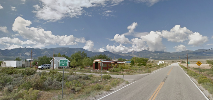
If you and 40 of your friends go visit Baker, Nevada, you’ll double the population of this small town on the Utah border.
Don’t let its size fool you.
The front and backyards are bigger than you can wrap your head around.
Great Basin National Park is just west of Baker, with adventures awaiting day and night, at the top of a 13,000-foot summit and nearly 500 feet below the earth in a cave.
The night skies are intoxicating here, whether you want to see it from atop a mountain ride or from your porch at the Stargazer Inn.
An archeological site is also nearby, dating back to the year 1220 AD.
Baker is part of the Great Basin region that includes White Pine County, Nevada, and Millard County, Utah.
It sits at the end (or beginning) of America’s Loneliest Road, Highway 50.
The Great Basin Highway can also take you straight into Las Vegas.
There’s also a forest of the world’s oldest trees, baking yet surviving in the brutal climate.
When you truly want to escape to the wilderness, you can’t beat the Great Basin.
You just need some safety advice to get you started.
Warnings & Dangers in Baker

OVERALL RISK: LOW
There's a low risk here for criminal activity, though I'll decline to dive into crime data because there are far bigger risks to talk about, like coyotes, abandoned mines, and wildfires to talk about.

TRANSPORT & TAXIS RISK: LOW
You'll need your own car to get here, and it's ideal if you rent a high-profile or four-wheel drive vehicle. A Toyota Corolla might not cut it here. I say that partially in homage to my good friend Carolyn who does things like run 100 miles through mountains for fun. Her Corolla made it through some unexpected roads but eventually got stuck in the deep sands of the desert. Nobody will be as lucky as Carolyn was. Get a tough car and know the "Dirt Road Code" as outlined in the Visit Nevada tourism site.

PICKPOCKETS RISK: LOW
The rates are low, and I'm 99% sure the 15 pickpockets reported in 2022 on the official crime data site are an error considering no pickpockets or purse snatchings were reported in the past previous five years. With so few people around, there aren't many choices of people to steal from, so keep your belongings secured and don't leave your car unlocked or with valuables inside.

NATURAL DISASTERS RISK: HIGH
Weather can turn on a dime here. The weather you get in Baker can be drastically different in the park or on the mountain. Look for wildfire risks any time of the year, and never ignore evacuation precautions or orders. If you see a storm forming in the distance, it will get there faster than you expect. Winter weather can be treacherous. Temperatures can get cold enough to give you hypothermia or hot enough to allow heat exhaustion or heat stroke to set in. Treat this as a high risk, so you research every element and make an escape plan for any emergency. Oh, the relentless winds are a problem too, and some can be strong enough to blow you off the side of a mountain if you aren't careful.

MUGGING RISK: LOW
No more than two robberies have happened in a year going back five years, so this is a low risk.

TERRORISM RISK: LOW
This is more of a place where terrorists would hide out instead of attacking. You should be careful on the highway because this lonely road is a great place for drug dealers to make a run. Several big busts have happened along the road.

SCAMS RISK: LOW
You'll have a low risk of being scammed here as this is a place not too many people will seek out. Of course, always be on the lookout for someone offering a deal too good to be true or begging for money with a creative sob story.

WOMEN TRAVELERS RISK: LOW
Provided women know wilderness safety that we'll go through in this article, there's no more risk for them than men. For the casual hiker, take your time and acclimate. Stick to places where park rangers are nearby. Don't hike alone. If you must be alone hiking or driving, always let someone know where you're going and when you plan to be back. It's also smart to let law enforcement know your solo plans.

TAP WATER RISK: LOW
Do not drink fresh water found in the desert. It can have bacteria or brain-eating amoebas. You can buy pellets and devices that will clean water, but that takes some time and patience. Bring extra water with you and drink as you go to stay hydrated. There's no concern about water quality at the locations in town.
Safest Places to Visit in Baker
Great Basin Heritage is a great website to start with to learn about both sides of the state line and Baker.
For planning purposes, you should know that the time zones change at the Utah state line.
Nevada is in the Pacific Time Zone, and Utah is in the Mountain TIme Zone, one hour ahead of Nevada.
Great Basin National Park is the official site of the National Park Service.
You can also download the park app to have information on your mobile device.
The Great Basin Visitor’s Center is in Baker.
The park has over 60 miles of hiking trails, ranging from easy nature walks to strenuous backcountry hikes.
Popular trails include the Bristlecone Pine Trail, which takes you through a grove of ancient trees, and the Wheeler Peak Summit Trail, which leads to the park’s highest point, more than 13,000 feet above sea level.
Stargazing tours are available seasonally, and you should check the park website for dates and times.
This is the safest way to experience the event and get expert guidance on what to look for in the skies above.
(Since Area 51 isn’t too far away, you might even see a UFO.
You know, if you believe in that kind of thing.)
Lehman Caves, located in the eastern part of the park, is a limestone cave system that features unique formations and intricate patterns.
Guided tours of the caves are available for a fee.
You can go on a “wild cave” self-guided tour, but you do need a permit after proving you have the knowledge and skills to navigate them.
You will need to bring your own cave gear.
Some of these caves are vertical, tight spaces, and have high levels of CO2. Oh, and bats.
Lots of them.
The park offers several scenic drives, including Wheeler Peak Scenic Drive and the 12-mile Snake Creek Canyon Scenic Drive.
During the winter months, visitors can enjoy snowshoeing, cross-country skiing, and snowmobiling in the park’s backcountry.
You should know avalanche safety and talk to locals and park rangers before you go to talk about the snowfall activity.
While the weather could be cold and snowy while you’re there, you need to know if the previous week or month had above-average temperatures that could make a slope unstable.
The park offers fishing in several streams and lakes, including Lehman Creek and Baker Creek.
A Nevada fishing license is required.
There are no reciprocity agreements between Utah and Nevada.
If you plan to fish in Utah as well, you’ll need a license in that state.
Just north of Highway 50 is the U.S. Forest Service land of Mount Moriah Wilderness.
You cannot drive in the wilderness area as part of the Forest Service preservation guidelines.
Stretching north and west of 12,050-foot Mount Moriah is a plateau known as The Table, a unique world of sub-alpine vegetation lined with bristlecone and limber pine.
Dry pinyon-juniper forestland dominates a large part of the lower elevations here.
Cave Lake State Park is another nearby (as nearby as things get in a remote option) place to explore, and this one would be ideal for anglers for the stocked trout lakes.
Fishing is allowed 24/7.
Choose from four hiking trails, but only one of them is considered easy.
The others are either moderate or strenuous.
The Great Basin Museum is 96 miles away in Utah, and more museums are 61 miles away in Ely (“ee-lee”).
Places to Avoid in Baker
The only place to avoid here is a location where you aren’t 100% sure you have the skills to survive an injury, animal encounter, or weather event.
For example, do you know what to do if you’re hiking the mountains?
- Great Basin National Park has rangers that patrol there. BLM lands have rangers as well. You should touch base with the sheriff’s office when you arrive to introduce yourself and let them know your plans. Follow them on Facebook @WhitePineCountySheriffsOffice.
- The Facebook page does have a daily police blotter posted so that you can get information about the daily 911 calls. This could be anything from a loud teen party to car break-ins to lost cattle.
- Speaking of cattle, this is free-range, and animals will wander wherever the heck they choose. That might be in the middle of the highway. Always keep an eye out for wildlife when driving.
- Altitude sickness can happen to those who don’t live in high-altitude climates. While it’s usually above 8,000′ that the worst of it kicks in, it can start with shortness of breath and dizziness at 5,000′. Baker is at 5,300′ feet. Stay hydrated throughout your trip. If you’re climbing a mountain and start to feel an impact, go back down the mountain until you find a place to rest and recover. Usually, a day or two in the valley can help ward off the more dangerous risks.
- Research Talus Slopes in the region and avoid them. These are slopes of loose rock that might look stable to the naked eye. One step could send you falling down the rocky edge and your ankle or knee flying in the other direction.
- Avoid going in or near any abandoned mines in the area. Sometimes there are thunderstorms, what to do if lightning develops? If you’re running under the closest tree, you’re wrong and at a higher risk.
The emergency management department for White Pine County, BLM, and National Park Service websites have a lot of information about all the risks here.
You should check wildfire activity, weather radar, air quality, and emergency notifications whenever you are in mobile phone range.
Don’t rely on that mobile phone, however.
You can download the NPS app and find maps to save to your phone that will work by GPS and won’t need a mobile signal.
Always bring a paper map, ideally one that is laminated.
Know how to use a compass.
Wildlife officials always recommend hiking in a group of at least three.
That was if one person gets injured, another can tend to the injuries while the third goes for help.
There’s also strength in numbers if you encounter aggressive wildlife.
Safety Tips for Traveling to Baker
- The White Pine County Sheriff’s Office is the law enforcement agency here. Thilver State for all the mining that happened here. Not every mine was properly closed off or shut down. You can also help by marking the GPS coordinates of any mine you come across and alerting the park ranger. There is an ongoing effort to seal off all mines. They just need to know where they are.
- Rattlesnakes live in this area, and you should know the basics of avoidance and first aid. You can buy snake bite kits with some basic essentials to treat the wound. While the best advice is to call 911, you won’t always have that luxury here. Never reach into a hole or area where you can’t see your hand. If you hear a rattlesnake (travel without earbuds in), back up slowly so you don’t inadvertently walk into its path. I can tell you from firsthand experience that those suckers are hard to see, even if you hear them.
- There are mountain lions in this area, but they really do a great job of staying away from you. If you happen to cross one’s path, never turn your back. Stay calm and raise your arms up to make yourself as “big” as possible. In the unlikely event of an attack, fight back. Coyotes also run free here, so keep an eye on small pets. They will also want very little to do with someone your size.
- The caves here will have bats. Stay as quiet as possible to avoid disturbing them. If you’re creeped out by them, just remember how many bugs they eat that won’t be bothering you at your campsite.
- When you’re out at night, use a flashlight with a red filter to be able to enjoy the night skies without losing a guiding light on the ground. There isn’t a bad place to view the night skies here, so don’t think you need to hike into a dangerous area to get a better view.
So... How Safe Is Baker Really?
With just 36 residents, it would be hard to think there’s a dangerous edge to Baker.
Crime data is only available for White Pine County as a whole, and that does include Ely and the state prison.
Violent crimes that happen in prison are registered in crime data.
For example, the stabbing death in at the Ely State Prison in December 2022 would be one of the two homicides in the county.
You do need to prepare for the worst and hope for the best.
That goes for long road trips far away from service stops, weather that can develop quickly, and wildfire/wilderness risks.
Use the Recreate Responsibly section of the Nevada tourism site to learn safety tips by car, vehicle, and ATV.
As much as getting into the wild sounds intriguing for some, it’s important to remember how few services there are here.
If you need to be rescued, first the crews have to find you, then they need to get you to Las Vegas or Salt Lake City for medical treatment.
If you get lost, it could be hours or days before you are found.
You need to have those survival skills ahead of time.
As with any adventure, start at your skill level.
Maybe stick with the national park and then build your confidence and knowledge to do better in the more remote and unmanaged areas.
This trip will be as safe as you make it.
How Does Baker Compare?
| City | Safety Index |
|---|---|
| 74 | |
| 77 | |
| 84 | |
| 76 | |
| 79 | |
| 75 | |
| 62 | |
| 72 | |
| 50 | |
| 78 | |
| 67 | |
| 80 | |
| 83 |
Useful Information

Visas
International guests need a passport that isn't within six months or expiring. A visa or visa waiver is required, but you'll need to look at the U.S. State Department website to see if you qualify for a waiver. Look for options that don't require an in-person interview, as that's where the main backlog happens.

Currency
The U.S. Dollar is the only currency you can use here. Do not wait until you are in the Great Basin to look for currency exchange. The best value comes at your home bank, where members get lower fees. Casinos will require you to use cash for slot machines and table games, but the ATM fees will be much higher than a regular bank ATM.

Weather
Four intense seasons reign here. While the majority of days will be sunny with turquoise skies, storms kick up quickly here. Always bring layers of clothing, even on hot days. If you get a sunburn, that long-sleeved shirt will be handy, even if you need to wrap it around your head. Worn-in hiking boots are a must, and make sure you have good ankle support and extra pairs of socks. Don't forget sunscreen, sunglasses, and a hat.

Airports
Salt Lake City International Airport is the closest at 230 miles away, but Harry Reid International Airport in Las Vegas is another option, 300 miles away. Remember, if you book a flight out of Salt Lake City that it's an hour ahead of Baker.

Travel Insurance
Travel insurance and adventure insurance are a must when traveling to a remote region and a part of the country prone to storms that delay flights and close roads.
Baker Weather Averages (Temperatures)
Average High/Low Temperature
| Temperature / Month | Jan | Feb | Mar | Apr | May | Jun | Jul | Aug | Sep | Oct | Nov | Dec |
|---|---|---|---|---|---|---|---|---|---|---|---|---|
| High °C |
6 | 8 | 12 | 16 | 21 | 29 | 33 | 31 | 26 | 18 | 12 | 6 |
| Low °C |
-4 | -3 | 1 | 4 | 8 | 14 | 19 | 18 | 13 | 6 | 1 | -4 |
| High °F |
43 | 46 | 54 | 61 | 70 | 84 | 91 | 88 | 79 | 64 | 54 | 43 |
| Low °F |
25 | 27 | 34 | 39 | 46 | 57 | 66 | 64 | 55 | 43 | 34 | 25 |
Nevada - Safety by City
| City | Safety Index |
|---|---|
| 74 | |
| 79 | |
| 76 | |
| 76 | |
| 74 | |
| 70 | |
| 82 | |
| 77 | |
| 72 | |
| 77 | |
| 77 | |
| 68 | |
| 78 | |
| 72 | |
| 62 | |
| 75 | |
| 76 | |
| 82 | |
| 78 | |
| 77 | |
| 54 | |
| 74 | |
| 78 | |
| 70 | |
| 76 | |
| 77 | |
| 76 | |
| 81 | |
| 79 | |
| 72 | |
| 73 |


Baker is a remote area with a sparse population and limited law enforcement presence. Due to its rural nature, crime rates may be lower compared to more urbanized areas. This town is a nice place to start a family.
Baker’s remote location means that residents may be more self-reliant for safety and security. However, it’s crucial for residents and visitors to take precautions, especially when traveling in isolated areas. We commit to strong community ties in here and we always got each other’s back!
While serious crimes like violent offenses are relatively rare in rural areas like Baker, property crimes such as theft, burglary, and vandalism may still occur. It’s essential for new residents to secure their property and remain vigilant.
Baker has this incredible isolation that really makes you feel like you’re in your own little world, and watching the stars from the Stargazer Inn felt like a privilege I didn’t know I needed.
I never imagined such a small place could have such stunning night skies; it’s like a whole different world out there when the stars come out.
Sat on the porch at the Stargazer Inn and the Milky Way looked like someone had tossed salt across the sky, which oddly made me feel calm and tiny.
Spent a night stargazing at the Inn there and honestly had no idea the sky could look that wild without city lights messing it up.