 Nevada : Safety by City
- Baker
- Battle Mountain
- Beatty
- Blue Diamond
- Boulder City
- Burning Man in Black Rock City
- Caliente
- Carson City
- Elko
- Fallon
- Fernley
- Henderson
- Incline Village
- Jackpot
- Las Vegas
- Laughlin
- Lovelock
- Minden
- Moapa Valley
- Mount Charleston
- North Las Vegas
- Pahrump
- Rachel
- Reno
- Searchlight
- Sparks
- Stateline
- Tonopah
- Virginia City
- West Wendover
- Winnemucca
Caliente, Nevada, gets its name from the Spanish word meaning “hot,” and the hot springs that earned the town that name still are one of the top attractions in town.
It’s also known as the “City of Roses” for the rich floral blooms that line the streets and sidewalks.
The town is 35 miles from the Utah border and 150 northeast of Las Vegas.
It’s the only incorporated town in rural Lincoln County and is surrounded by some lesser-known desert secret outdoor spaces waiting to be explored.
Caliente has made headlines for all the wrong reasons.
It is a Church of Jesus Christ of Latter Day Saints stronghold, but the extreme branch of that religion led by Warren Jeffs has connections here too.
In the federal case against Jeff, it is stated that the Hot Springs Hotel was used to bring child brides to get married, given Nevada’s liberal marriage laws.
Today Caliente keeps the historic spirit alive of its more honorable ancestors, and it’s an oasis in the middle of an unforgiving desert.
The town is surrounded by as many natural wonders as risks since flooding is common during the spring snow run-off.
Several times in history, this town has almost been flooded off the map.
Each time it was rebuilt.
What it lacks in a major roadway it offers in scenic views on a winding interstate that drives you right into the heart of Southern Utah’s wilderness, with Bryce Canyon being three hours away.
Warnings & Dangers in Caliente

OVERALL RISK: LOW
There's a low risk here with a small town of fewer than 1,000 people. In full transparency, there isn't official crime data for the city or county since 2020, but even then, the numbers were consistently low.

TRANSPORT & TAXIS RISK: LOW
You'll need your own vehicle here. There's no public transportation, but you might be able to call an occasional taxi or rideshare.

PICKPOCKETS RISK: LOW
The risk is low, but not low enough to let your guard down. I'd be more worried about leaving valuables in your car or around a campsite.

NATURAL DISASTERS RISK: MEDIUM
Flooding and wildfires are the biggest risks here, with both causing problems from road closures to evacuations over the years. In spring 2023, even the main road into Utah was closed for weeks due to flooding and resulting road damage. Extreme heat and cold can cause issues, and winter weather should always be considered when planning a trip here. The risk is medium but can be lowered with education and research on these risks.

MUGGING RISK: LOW
This is another low risk. The bigger concern would be people who have committed crimes driving through this area to escape, taking the less-traveled route to avoid law enforcement.

TERRORISM RISK: LOW
In a small town like this, there's no reason to be worried about international terrorism. Nearby, Panaca did have a bombing after a disgruntled employee blew up a co-worker's home. That's a rare occurrence, but still worth noting.

SCAMS RISK: LOW
Scams here are targeted at residents, and there's a low risk for a tourist. You might have a Mormon church member knock on your door or approach you in town to preach the gospel. This is quite common, but you are under no obligation to listen.

WOMEN TRAVELERS RISK: LOW
Women shouldn't have a worry here, aside from being prepared for a drive through a very rural part of the state. It will help to know how to change a tire or stock a car with emergency supplies. Great advice for any gender is to avoid exploring the wilderness areas alone.

TAP WATER RISK: LOW
You should ask the hotel or rental home for the latest water quality testing, as a formal report isn't produced each year. There's no ongoing risk to the water, but after flooding, you should always ask if the water is safe to drink.
Safest Places to Visit in Caliente
Lincoln County, Nevada, has a travel guide that’s worth downloading.
You don’t have to give any personal information, which is always a bonus.
Places like Caliente and Lincoln County have become more popular since the pandemic.
People who wanted to get away from the virus risk while enjoying the great outdoors searched for rural escapes.
That’s just what Lincoln County has always been and will continue to be.
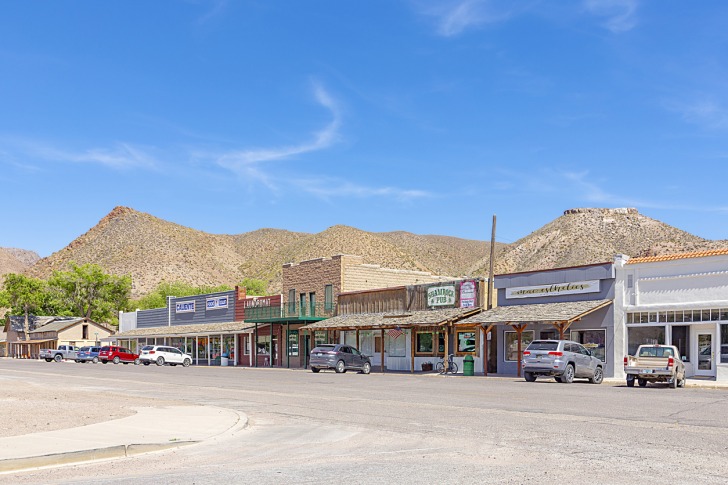
While you can drive through Caliente in less than five minutes, let’s talk about what you’ll find in that short two-mile stretch of road.
First, Calient is surrounded by mountains in the immediate area.
Many Nevada cities have mountains on the horizon.
In Caliente, they are right *there.
Just about every Nevada town is a “Railroad Town,” but Caliente has special claims to fame you can learn about at the Box Car Museum.
The mission-style depot is a show-stopper in itself, but the history inside will really impress you too.
Caliente Hot Springs Motel and Spa isn’t anything fancy, but you can enjoy the nutrient-rich water in your room or at the spa.
Other towns in Lincoln Couty worth exploring are:
- Pioche: “Nevada’s Liveliest Ghost Town”
- Panaca: Oldest Town in Eastern Nevada
- Alamo: Beginning of the Extraterrestrial Highway
- Elgin: A ghost town with one schoolhouse museum
- Rachel: “The UFO Capital of the World”
Rainbow Canyon is just south of Caliente and is home to Kershaw-Ryan State Park.
You can hike here or take the scenic route.
Check out the maps provided by the tourism department to find the outdoor activity for yourself.
Lincoln County has 10,000 square miles of places to explore, and only 2% of that land is privately owned.
That means you can hike wherever you want, but it’s safest to stick to designated federal lands or state parks.
Places to Avoid in Caliente
The town is very small, and there’s no “wrong side of the tracks” here.
It’s worth noting that people who aren’t Mormons can’t go into the temple of the churches.
You should avoid coming here without checking all the road conditions nearby.
Even as I write this, there are major roadways closed, and several portions of the parks and federal land are closed due to flooding.
Many roads in the wilderness areas aren’t paved.
You can review the “Dirt Road Code” and “Tread Lightly” road rules on tourism websites.
Off-roading opportunities should only be attempted if you have a high-clearance vehicle.
If you break down or need help, you’ll likely have to walk a while to get it.
Keep that in mind as you drive to your destination.
Review the emergency safety kits to carry in vehicles, and you should learn how to purify water that you find in the desert.
Even though it’s freshwater, there are bacteria that can make you sick.
Never immerse your head in hot springs water to eliminate the small but mortal risk of getting a brain-eating amoeba.
Safety Tips for Traveling to Caliente
- Law enforcement in Caliente is provided by the Lincoln County Sheriff’s Office. Since Lincoln County is a popular name across the country, you can find the right social media page @lincolncountysherriffsofficenevada.
- Sign up for emergency notifications through the CodeRED system. This is especially important in the rural area prone to developing weather situations. You can also follow Lincoln County Emergency Management on Facebook @LCEM1.
- Stick by the Leave No Trace principles you can find on lnt.org. This means you leave the wilderness as you found it. Take nothing from the wild and leave nothing behind. Bring all your trash with you and leave behind rocks, flowers, or fossils. If you are bringing a pet, bag and carry the waste out with you.
- Bring a GPS system and a paper map with you. Ideally, get a map that has a coating on it to prevent it from tearing or being impacted by fluid spills. Your mobile service will be spotty (at best), and trying to find a signal could drain the battery quickly. T-Mobile customers likely won’t get any service anywhere in the county.
- This is all open range in Lincoln County. That means the wildlife and cattle can roam as they please. This could cause a traffic accident if you aren’t paying attention to the road. There’s nothing stopping a cow from chilling in the middle of the road for a while.
- The Lincoln County website has a bunch of great videos that show you all the attractions but also offer safety advice for each one.
- Use the Inciweb website to check for wildfire activity in Lincoln County and across the West. A fire burning nearby can quickly shift directions with the wind, and even smoke from a far-away fire can impact air quality.
- Never try to cross a flooded road. Not only can the water carry you away with just six inches of current, but the road beneath the flood could be ready to crumble.
- Check the alerts on each park or public land website. Most places here are managed by the state of Nevada or the Bureau of Land Management (BLM).
- Know the difference between a hiking trail and a mountain bike trail, as there are many in Lincoln County. YOu don’t want to risk being in a trail accident with a mountain biker. Ask someone at city hall for the latest trail information since new ones are always being added.
So... How Safe Is Caliente Really?
Caliente’s risks are the natural and wilderness kind, not the crime rate kind.
The rates here are low, even without having the exact raw data.
Historically, the few crimes that do happen here are among people who know each other.
That’s never an excuse to let down your guard.
You are more likely to run into a cow on the highway than a robbery on Main Street.
The extreme weather here is worth researching as well.
Summer can bring temperatures in the triple digits during the day while still falling close to freezing at night.
The air is very dry, and dehydration can set in quickly.
Snakes, scorpions, and other dangerous animals are in the wilderness.
Winter can also bring snow at different elevations.
While it might be mild in the towns, the upper elevations can be getting a major snowstorm.
Two-thirds of a trip to this region is preparation and education.
The other third is making smart choices based on your skill sets and survival knowledge.
This is truly an unplugged, remote area.
Whether that’s a scary or exciting prospect depends on how ready you are for what lies ahead.
How Does Caliente Compare?
| City | Safety Index |
|---|---|
| 82 | |
| 66 | |
| 72 | |
| 78 | |
| 76 | |
| 91 | |
| 48 | |
| 64 | |
| 65 | |
| 96 | |
| 61 | |
| 76 |
Useful Information

Visas
International travelers need a passport and visa to get through Customs at the airport. Some people might be able to qualify for a Visa Waiver, but you'll need to get the rules on the U.S. State Department website. You can travel between states here without showing additional ID.

Currency
The U.S. Dollar is the only currency accepted here. There might be cash-only restaurants, so carry paper bills with you but keep them in a secure spot. Only carry the cash you need with you. If you plan on gambling, you'll need dollars to put into the slot machines or get to chips for table games.

Weather
Bring layers of clothing during all seasons. Sunscreen, sunglasses, a hat, and clothing with UV filters all help brave the elements. You need worn-in hiking boots to handle the rugged terrain. There can be a lot of dust here too, so bring clothing that can get dirty.

Airports
Harry Reid International Airport (formerly McCarran International Airport) in Las Vegas is the closest option, and that drive will take just under three hours. Salt Lake City's airport is a five-hour drive.

Travel Insurance
When purchasing travel insurance, explore options that involve adventures in rural spaces. You want to make sure you have coverage for extended rescues, accidents, or mishaps along the way. Definitely get as much rental car insurance as you can.
Caliente Weather Averages (Temperatures)
Average High/Low Temperature
| Temperature / Month | Jan | Feb | Mar | Apr | May | Jun | Jul | Aug | Sep | Oct | Nov | Dec |
|---|---|---|---|---|---|---|---|---|---|---|---|---|
| High °C |
8 | 12 | 15 | 20 | 25 | 31 | 34 | 33 | 29 | 22 | 13 | 8 |
| Low °C |
-6 | -4 | -1 | 2 | 6 | 10 | 14 | 14 | 8 | 2 | -3 | -7 |
| High °F |
46 | 54 | 59 | 68 | 77 | 88 | 93 | 91 | 84 | 72 | 55 | 46 |
| Low °F |
21 | 25 | 30 | 36 | 43 | 50 | 57 | 57 | 46 | 36 | 27 | 19 |
Nevada - Safety by City
| City | Safety Index |
|---|---|
| 74 | |
| 79 | |
| 76 | |
| 76 | |
| 74 | |
| 70 | |
| 82 | |
| 77 | |
| 72 | |
| 77 | |
| 77 | |
| 68 | |
| 78 | |
| 72 | |
| 62 | |
| 75 | |
| 76 | |
| 82 | |
| 78 | |
| 77 | |
| 54 | |
| 74 | |
| 78 | |
| 70 | |
| 76 | |
| 77 | |
| 76 | |
| 81 | |
| 79 | |
| 72 | |
| 73 |


It’s wild to think this little town has been through so much yet still thrives with its hot springs and blooming roses, feels like a hidden gem just waiting for someone to uncover its quirky charm.
Just got back from exploring Caliente, and I have to say those hot springs really do feel like a little slice of heaven amidst all the desert scenery.
I didn’t know the history behind Caliente’s name, but the idea of those hot springs being a centerpiece in such a rugged landscape is pretty fascinating.
Walking past the Hot Springs Hotel sign gave me chills, the roses smelled so sweet it felt almost eerie.
Have you noticed if the flooding still causes major issues during spring, or has the town figured out a way to manage it better?