


 Argentina : Safety by City
- Buenos Aires
- Cordoba
- El Calafate
- El Chaltén
- La Plata
- Mar del Plata
- Mendoza
- Neuquen
- Puerto Iguazu
- Puerto Madryn
- Rosario
- Salta
- San Carlos de Bariloche
- San Miguel de Tucuman
- Ushuaia
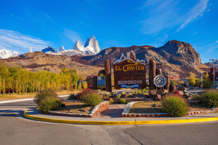
El Chaltén is a tiny mountain town in Argentina’s Santa Cruz Province, tucked inside the northern section of Los Glaciares National Park near the Chilean border.
It sits beneath the dramatic granite peaks of Mount Fitz Roy and Cerro Torre, making it one of the most famous trekking bases in Patagonia.
Argentina officially recognizes El Chaltén as the country’s National Capital of Trekking, and the title feels well earned.
Several major trails begin directly from town, allowing travelers to walk from a bakery to a glacier viewpoint without needing a car.
Crime is very low, the community is welcoming, and the scenery is extraordinary.
However, El Chaltén’s greatest dangers are environmental rather than criminal.
Powerful winds, sudden storms, steep trails, cold water, winter ice, limited medical facilities, and poor preparation can turn a beautiful hiking day into a serious emergency.
Warnings & Dangers in El Chaltén

OVERALL RISK: LOW
El Chaltén is one of Argentina’s safer destinations for street crime. Violent incidents involving tourists are rare, and the compact town feels comfortable during the day and evening. The main risks come from hiking accidents, unpredictable weather, inadequate equipment, road travel, and delayed emergency assistance in remote areas.

TRANSPORT & TAXIS RISK: LOW
Transport in El Chaltén is generally safe, but choices are limited. Most visitors arrive by bus, rental car, or private transfer from El Calafate. Roads are paved but exposed to wind, ice, and wildlife. Taxis are limited, so confirm transportation in advance and avoid driving tired or during severe weather.

PICKPOCKETS RISK: LOW
Pickpocketing is uncommon in El Chaltén. The town does not have the crowded transport networks or organized theft problems found in major cities. Still, watch your phone, wallet, hiking equipment, and luggage in bus terminals, hostels, restaurants, trailheads, and busy campsites during the summer trekking season.

NATURAL DISASTERS RISK: MEDIUM
Natural hazards are the main concern. Patagonia is known for sudden wind, rain, snow, freezing temperatures, wildfires, landslides, and rapidly changing visibility. Mountain conditions may deteriorate within minutes. Travelers must check trail conditions, carry suitable clothing, obey closures, and turn back when the weather becomes unsafe.

MUGGING RISK: LOW
Muggings are extremely rare in central El Chaltén. Visitors commonly walk between restaurants, hotels, and hostels without difficulty. The greater concern is isolation on quiet trails or roads rather than deliberate street violence. Avoid carrying excessive cash, secure accommodation doors, and do not leave valuables unattended at campsites.

TERRORISM RISK: LOW
The terrorism risk in El Chaltén is very low. It is a remote mountain community with no significant political, military, or symbolic profile. Travelers should devote far more attention to hiking safety, weather forecasts, wildfire restrictions, transportation planning, and emergency communication than to terrorism.

SCAMS RISK: LOW
Tourist scams are uncommon. The most likely problems involve unclear tour cancellation terms, inflated seasonal prices, unofficial transportation offers, or confusion over exchange rates. Book excursions through established operators, confirm what equipment is included, and understand refund policies because hiking and boat tours may be canceled due to weather.

WOMEN TRAVELERS RISK: LOW
El Chaltén is generally safe for women, including solo travelers. The town has a friendly backpacking culture, and popular trails receive steady foot traffic during high season. Solo hikers should still share their route, avoid remote trails near sunset, carry emergency supplies, and use extra caution around alcohol and shared accommodation.

TAP WATER RISK: MEDIUM
Tap water is commonly used in El Chaltén, but the town’s sanitation infrastructure has faced pressure from rapid tourism growth. Water conditions may also vary between buildings and during service problems. Ask your accommodation for current advice, and use bottled, boiled, or properly filtered water if local warnings are issued.
Safest Places to Visit in El Chaltén
El Chaltén Village Center
The compact village center is extremely safe and easy to explore on foot.
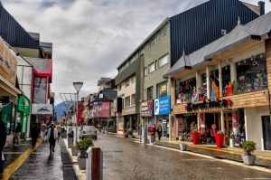
Restaurants, bakeries, outdoor shops, hostels, hotels, and tour offices are concentrated along a small number of streets.
Even after sunset, the central area usually feels comfortable, although sidewalks can be uneven and icy during colder months.
Mirador de los Cóndores
This short trail begins close to the national park visitor center and leads to a panoramic viewpoint above town.
It is one of the safest introductions to hiking in El Chaltén because it is relatively short, well known, and close to assistance.
Strong wind is the main concern near the exposed viewpoint.
Laguna Capri
Laguna Capri is a popular destination on the route toward Mount Fitz Roy.
It offers forest scenery, mountain views, and a designated camping area.
The trail is generally safe in good weather, but it still requires suitable footwear, water, layers, and enough daylight for the return journey.
Chorrillo del Salto
Chorrillo del Salto is a forest waterfall that can be reached by a relatively gentle walking route or short road transfer.
It is a good option for families and travelers seeking a lighter activity.
Stay on marked paths, watch for slippery rocks, and keep away from unstable river edges.
Laguna Torre Trail
The Laguna Torre route is one of the area’s classic hikes and is generally manageable for prepared walkers during the main trekking season.
The trail is popular and reasonably clear, but it remains a long mountain outing.
Wind, rain, mud, cold, and changing visibility should never be underestimated.
Places to Avoid in El Chaltén
Laguna de los Tres in Dangerous Weather
Laguna de los Tres offers the famous close-up view of Mount Fitz Roy, but the final ascent is steep, rocky, and exposed.
Avoid this section during high wind, snow, ice, heavy rain, poor visibility, or late in the day.
Turning back is the correct decision when conditions deteriorate.
Closed or Restricted Trails
Never ignore a closure sign or attempt to bypass a ranger’s instructions.
Trails may close because of fire danger, flooding, damaged bridges, ice, deep snow, rockfall, or rescue operations.
A route that looked safe in an older travel guide may not be safe on the day of your visit.
Remote Backcountry Areas Without Registration
Climbing routes and remote trekking areas require greater experience, equipment, and planning than the popular day hikes.
Some activities require registration with park authorities.
Do not enter glaciers, technical climbing zones, or isolated valleys without appropriate skills, navigation equipment, and current local information.
Riverbanks During High Water
The Fitz Roy, De las Vueltas, and other rivers can become dangerous after heavy rain or rapid snowmelt.
Avoid unstable banks, improvised crossings, and flooded paths.
Glacier-fed water is extremely cold, and even a minor fall can become life-threatening if the current is strong.
Trails After Dark
Popular routes become much harder to follow after sunset, particularly in forests or bad weather.
Temperatures drop quickly, wildlife and loose terrain become harder to see, and rescue response may take hours.
Start early, monitor your pace, and turn around before daylight becomes a problem.
Safety Tips for Traveling to El Chaltén
- Check the forecast every morning. Patagonian weather changes quickly, and a sunny start does not guarantee a calm afternoon. Check wind, precipitation, temperature, visibility, and official trail information before leaving. Ask park staff or local guides when conditions are uncertain. Change your itinerary rather than forcing a hike during a dangerous weather window.
- Carry layers in every season. A proper layering system should include a moisture-managing base layer, warm middle layer, windproof outer layer, and waterproof jacket. Pack gloves and a warm hat even in summer. Strong wind and rain can lower your body temperature rapidly, especially when you stop moving at a viewpoint.
- Wear genuine hiking footwear. El Chaltén’s trails include mud, loose stones, roots, steep climbs, and wet rock. Shoes should have reliable grip and enough support for the route. New or poorly fitting boots can cause blisters that become painful several hours from town. Break footwear in before attempting a major hike.
- Start long hikes early. Routes such as Laguna de los Tres and Laguna Torre require several hours. Starting early gives you more daylight, allows time for rest, and provides flexibility if the weather changes. Do not begin a major trail in the afternoon simply because other hikers are still returning from it.
- Tell someone where you are going. Share your route and expected return time with your hotel, hostel, travel partner, or family member. Register when required for remote trekking or climbing. Mobile service may disappear outside town, so do not assume you can call for help from every section of the trail.
- Carry enough food and water. Bring more water and food than you expect to need, especially on long routes. Snacks should be easy to eat while hiking and provide useful energy. Do not rely on finding shops, cafes, or treated water once you leave town. Treat natural water before drinking it.
- Respect the wind. Patagonian gusts can affect balance, slam doors, carry loose objects, and make exposed viewpoints unsafe. Use trekking poles if they improve your stability, secure hats and equipment, and keep away from cliff edges. If walking becomes difficult, crouch lower, seek shelter, or turn back.
- Download offline maps. Download trail maps before leaving your accommodation and carry a power bank. A paper map is also useful for longer routes. Popular trails are usually clear, but snow, fog, darkness, or accidental detours can make navigation difficult. Never rely entirely on mobile reception or a single electronic device.
- Follow fire restrictions. Wildfire is a serious threat in Patagonia’s dry and windy conditions. Use only authorized cooking areas, obey all fire bans, and extinguish permitted stoves completely. Never discard cigarettes or burn rubbish. A small flame can spread quickly when powerful wind reaches dry grass or forest.
- Know when to turn around. Reaching a viewpoint is optional. Returning safely is not. Turn back if weather worsens, visibility disappears, someone becomes exhausted, equipment fails, or the trail becomes icy beyond your ability. Mountains will still be there tomorrow. Pride is a remarkably poor substitute for rescue equipment.
So... How Safe Is El Chaltén Really?
El Chaltén is very safe when safety is measured by crime.
It is a small community built around trekking, tourism, and outdoor recreation, and serious violence against visitors is uncommon.
Most travelers comfortably walk through town, eat in local restaurants, stay in hostels, and reach trailheads without feeling threatened.
The more important safety calculation begins where the pavement ends.
El Chaltén stands inside a remote mountain environment where weather, distance, and terrain can quickly magnify small mistakes.
The Laguna de los Tres route, for example, covers roughly 25 kilometers on a full round trip and ends with a demanding climb.
An injured traveler may need to wait hours while rescuers reach the location on foot.
Wind is another defining hazard.
Patagonia’s strongest gusts can destabilize hikers, reduce body temperature, and make exposed areas dangerous.
Rain may turn trails muddy, while snow and ice can remain outside the coldest part of winter.
From May through September, registration requirements and specialist equipment may apply to routes that are straightforward during summer.
El Chaltén also has limited medical resources.
Minor injuries can be treated locally, but serious cases may require transfer to El Calafate or farther away.
This makes prevention particularly important.
My honest assessment is that El Chaltén has a low overall risk for prepared visitors and a medium or high risk for poorly equipped hikers.
Treat the town casually, but never treat its mountains casually.
How Does El Chaltén Compare?
| City | Safety Index |
|---|---|
| El Chaltén |
91 |
| Ushuaia |
68 |
| La Plata |
68 |
| Puerto Madryn |
70 |
| Neuquen |
58 |
| San Miguel de Tucuman |
32 |
| Mar del Plata |
76 |
 Yokohama Yokohama | 87 |
 Bucharest Bucharest | 70 |
 Council Grove Council Grove | 87 |
| Warwick | 85 |
| Yellow Springs | 74 |
| Cordova | 62 |
Useful Information

Visas
Citizens of the United States, Canada, the United Kingdom, the European Union, Australia, and many other countries can normally visit Argentina without a tourist visa for up to 90 days. Visa-free entry has no application fee. Other nationalities must apply through an Argentine consulate, with fees depending on citizenship and location.

Currency
Argentina uses the Argentine peso. Cards are accepted by many hotels, restaurants, and shops, but internet outages can interrupt payment systems. Carry some cash for small businesses and emergencies. Exchange rates can change rapidly, so compare official bank, card, and authorized exchange options shortly before traveling.

Weather
El Chaltén has cool, windy, and highly changeable weather. The main hiking season runs approximately from October through April, with long summer daylight but no guarantee of warmth. Pack waterproof clothing, insulating layers, gloves, a warm hat, sunscreen, sunglasses, and hiking shoes with strong grip.

Airports
The nearest major airport is Comandante Armando Tola International Airport near El Calafate. El Chaltén is roughly 200 to 220 kilometers away by paved road, usually requiring about three hours by bus, rental car, or private transfer. Book transport ahead during the busy summer trekking season.

Travel Insurance
Travel insurance is strongly recommended, especially for hiking, climbing, camping, or winter travel. Choose a policy covering medical treatment, evacuation, search and rescue, trip cancellation, lost equipment, and weather disruption. Confirm that trekking at your planned elevation and any technical activities are specifically included.
El Chaltén Weather Averages (Temperatures)
Average High/Low Temperature
| Temperature / Month | Jan | Feb | Mar | Apr | May | Jun | Jul | Aug | Sep | Oct | Nov | Dec |
|---|---|---|---|---|---|---|---|---|---|---|---|---|
| High °C |
18 | 16 | 13 | 10 | 6 | 3 | 2 | 4 | 7 | 11 | 14 | 17 |
| Low °C |
7 | 6 | 4 | 2 | -1 | -3 | -4 | -3 | -1 | 1 | 3 | 5 |
| High °F |
64 | 61 | 55 | 50 | 43 | 37 | 36 | 39 | 45 | 52 | 57 | 63 |
| Low °F |
45 | 43 | 39 | 36 | 30 | 27 | 25 | 27 | 30 | 34 | 37 | 41 |
Argentina - Safety by City
| City | Safety Index |
|---|---|
| Buenos Aires | 65 |
| Cordoba | 61 |
| El Calafate | 78 |
| El Chaltén | 91 |
| La Plata | 68 |
| Mar del Plata | 76 |
| Mendoza | 68 |
| Neuquen | 58 |
| Puerto Iguazu | 73 |
| Puerto Madryn | 70 |
| Rosario | 32 |
| Salta | 54 |
| San Carlos de Bariloche | 76 |
| San Miguel de Tucuman | 32 |
| Ushuaia | 68 |











Because who doesn’t love risking hypothermia right after grabbing a croissant from the bakery?
The wind is no joke there, caught me off guard on a quick hike near Fitz Roy.
I had high hopes but the wind there was actually so strong it almost knocked me over, makes you realize how careful you have to be out there.