 Washington : Safety by City
- Anacortes
- Bainbridge Island
- Bellevue
- Diablo
- Forks
- Gig Harbor
- Kennewick
- Kent
- Kettle Falls
- Longview
- Mercer Island
- Moses Lake
- Neah Bay
- Ocean Shores
- Olympia
- Port Angeles
- Port Townsend
- Poulsbo
- Pullman
- Quinault
- Renton
- San Juan Islands
- Seabrook
- Seattle
- Sequim
- Snoqualmie
- Spokane
- Spokane Valley
- Tacoma
- Walla Walla
- Wenatchee
- Westport
- Yakima
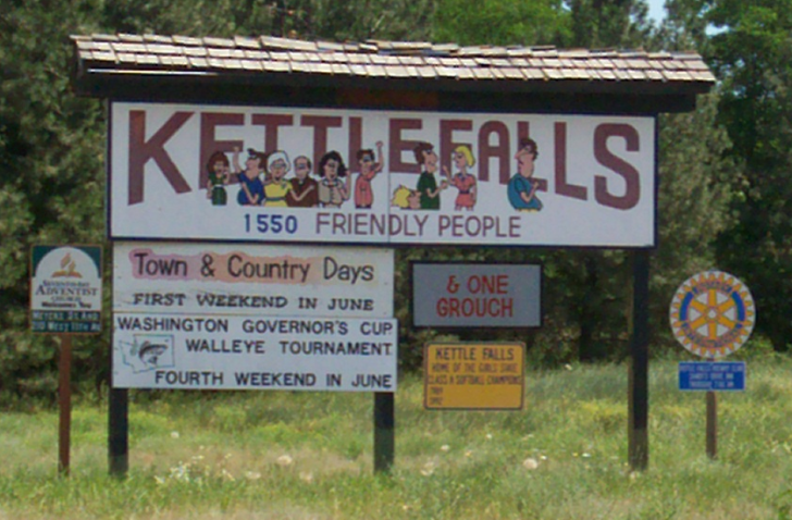
Kettle Falls, Washington, is a small town in far northeastern Washington, just 30 miles from the Canadian border.
The town is named after a waterfall that no longer exists.
It was covered by Lake Roosevelt when Grand Coulee Dam was created.
Even the original townsite had to be moved to the current location to avoid part of it being submerged.
Historically, Kettle Falls was an essential fishing site for the Native American tribes of the region, particularly the Spokane and Colville tribes.
The original Kettle Falls, a significant waterfall on the Columbia River, was an important site for salmon fishing and played a central role in the local indigenous culture.
The controversy centered on the loss of this critical natural resource and its impact on the indigenous peoples.
Submerging Kettle Falls effectively ended the traditional fishing practices that had been central to the tribes’ way of life for millennia.
Kettle Falls today retains much of its historical charm, but the true showstopper comes with the surrounding landscape of mountains, rivers, lakes, and waterfalls.
The area is a gateway to various outdoor recreational activities, including fishing, boating, hiking, and camping, particularly within the Lake Roosevelt National Recreation Area and Colville National Forest.
NOTE:
There is also a Kettle Falls in Voyageurs National Park in Minnesota.
Don’t get your research mixed up between the two.
Kettle Falls in Minnesota is only reached by water.
Warnings & Dangers in Kettle Falls

OVERALL RISK: LOW
There's a low risk in Kettle Falls when it comes to crime, but you'll need to know a lot about outdoor and wilderness safety to keep the risk low for other adventures.

TRANSPORT & TAXIS RISK: LOW
You'll need a car to get here, as this is a remote area. Public transportation here is for residents, and it's not a very robust service anyway. Don't expect taxis or rideshares to be available.

PICKPOCKETS RISK: LOW
The theft rate is low, and pickpockets or purse snatchings are rare. Even with the low risk, you should still take standard steps like locking your car, rolling up the windows, and keeping food secure. That's to avoid thieves of the human and bear kinds.

NATURAL DISASTERS RISK: MEDIUM
Kettle Falls, WA, is susceptible to several natural disaster risks, including wildfires, floods, and earthquakes. The area is part of a region prone to wildfires due to dry, hot summers and forested terrain. Flooding can occur, particularly near the Columbia River, though it's less frequent.

MUGGING RISK: LOW
Robberies are few and far between, with two being the most reported in the past decade. You want to use basic safety steps, but again, be more worried about a bear getting into your campsite or car than a criminal.

TERRORISM RISK: LOW
The risk is very low, considering the millions of acres of wilderness that surround Kettle Falls.

SCAMS RISK: LOW
The police department and local sheriff’s office will post the latest scams on social media. Check the fraud section of each department’s website for more information and to learn about common tactics.

WOMEN TRAVELERS RISK: LOW
Women have the same low risk but should use extra caution on trails with small children. Know the difficulty level of a trail and always bring enough water and supplies to last 24 hours or more in the event of an accident or getting lost.

TAP WATER RISK: LOW
The U.S. has strict standards for tap water per the Safe Water Drinking Act. Communities are required to provide a Water Quality Report (Consumer Confidence Report) once a year by July 1. The tap water in Kettle Falls is safe to drink, but you'll need a way to treat water found in the wilderness. Talk to a park ranger about any potable water access points. These are usually only available in the summer.
Safest Places to Visit in Kettle Falls
While Kettle Falls is located in Lake Roosevelt National Recreation Area, it’s important to note that the Grand Coulee Dam, which creates the lake, is about 100 miles away.
Kettle Falls is much closer to the northern end of the NRA, which goes as far as China Bend.
The National Park Service website for the NRA is the best place to start to learn about the park.
Each property of NPS has a four-letter code, and this one is LARO.
To visit the Chamber of Commerce website for Kettle Falls, visit kfchamber.org.
When you get to town, there’s an information center with plenty of information.
Another great resource is the Stevens County tourism website, which is itsreal.life/stevens-county.
You can also visit the Colville Chamber of Commerce website, as that city is just nine miles east of Kettle Falls.
Kettle Falls is mostly a stopping point for campers, hikers, boaters, and anglers picking up supplies.
You won’t find museums or major attractions here, but you can’t beat the outdoor options.
NOTE:
Check the progress of the Kettle Falls Historical Center, which was closed for a while due to water damage.
However, renovations are being done, and plans are to reopen it in the next few years if it’s not open already when you read this.
There’s a campsite on Lake Roosevelt managed by the National Park Service.
Larger groups should look at the Locust Grove campsites, which are located near the old town of Kettle Falls.
There’s a hiking trail that winds five miles along this shoreline to the old townsite, too.
The Sherman Pass/Crystal Falls Scenic Byway spans 70 miles, with Kettle Falls on the eastern edge.
You’ll also ride the highest maintained pass in Washington, at 5,575 feet.
Places to Avoid in Kettle Falls
There aren’t bad parts of Kettle Falls, and crime is nearly non-existent here.
While you should still take safety precautions, like locking your car at trailheads or in parking areas, the bigger risks come with the outdoors.
You should understand how remote and isolated this region is.
While there will be more crowded spots, especially on a hot summer day, it only takes hiking a mile or two before you’re alone in the wilderness.
Avoid hiking alone, and always let someone know where you are going and when you plan to be back.
Research the permits and/or reservations needed for camping, backcountry exploration, or other activities beyond day trips.
Also, unless you’re a winter adventurer with a lot of experience, you might want to skip a winter trip.
Kettle Falls is one of the few campgrounds in the National Recreation Area open in winter.
Even the visitor centers are closed from early September through late May.
You can still hike, snowshoe, or ski on certain trails, but it’s critical that you check the park alerts and access information.
The Facebook page is @LakeRooseveltNRA, where updates are posted throughout the year.
Expect snow and ice on the trails well into May, especially at higher elevations.
Also, avoid going into the wilderness without bear spray.
It could save your life if a grizzly bear approaches.
Safety Tips for Traveling to Kettle Falls
- Kettle Falls does have a local police department. You can reach them at (509) 738-6821 if you have specific safety questions. It’s smart to also follow the Stevens County Sheriff’s Office on Facebook @stevenscountysheriff. Their phone number is (509)684-5296.
- Stevens County uses Hyper-Reach to send out emergency notifications. You can sign up easily for free through the Emergency Management Department on the county’s website. These alerts will include severe weather, winter weather, and public safety threats.
- Bring a NOAA battery-powered weather radio to also get alerts, since mobile service is limited in this region. You will need to program the right channels on a weather radio, and usually, the fire department or emergency management employees can help you program that.
- Download the National Park Service app to get alerts and information about Lake Roosevelt National Recreation Area. You can download maps to use offline, but be sure to download them when you have a strong internet connection.
- Plot out an evacuation route before your trip, knowing that you might have only minutes to get out of the way of a wildfire, avalanche, or blizzard. The Washington State Department of Transportation’s real-time map will be a valuable resource during an emergency, showing road closures and detours.
- Fishing requires a license from the Washington State Department of Fish & Wildlife. You can get a license online or at a local outfitter. Be sure to carry the license with you at all times while fishing. If you plan to fish on the reservation, you’ll need a special permit for that through the Colville Tribes’ website.
- Permits are required for boating or paddling activities on Lake Roosevelt. You can pay on-site or through the National Park Service’s website. Washington also requires a boating education card and a mandatory safety class before you can use a boat with more than 15 horsepower.
- For any activities on the water from fall through spring, check the Lake Roosevelt water levels. Summer is the only season the lake stays filled. You can call (800) 824-4916 to get the latest water levels from the Bureau of Reclamation.
- If you see an airplane approaching the lake that seems way too low, it’s likely an aircraft picking up water for a wildfire. Get out of the way as quickly as possible and check with a ranger to see how many more pickups will happen. When a fire is burning, firefighting planes and helicopters go to any water source, even backyard pools, when available. The planes won’t stop or slow down for someone in their way.
- For those heading to Colville National Forest, it’s a property of the U.S. Forest Service. You’ll need to review the various rules and restrictions for that area. Be extra careful when going deep into the forest when there are burn restrictions or red flag warnings. Should a fire start, you’ll need to rely on yourself for survival as there aren’t many rangers or roads in the region.
So... How Safe Is Kettle Falls Really?
This is normally the part where I’ll go into exquisite detail about crime data, trends, and anomalies.
However, Kettle Falls has such low crime reports that it’s hard to tell you anything more than a few sentences.
The city of 1,200 people hasn’t had more than seven violent crimes in a year going back to the year 2000.
The year with seven crimes was 2022, and in 2023, the number was down to two.
Over the past five years, just three victims of violent crime were unknown to their assailant.
Even thefts are astonishingly low, with just 16 reported in 2023.
In the past decade, there haven’t been more than 22 in one year.
Even car break-ins amounted to two dozen in the past five years.
In surrounding Stevens County, just 45 violent crimes were reported.
That’s 75% lower than the national and state averages.
In fact, one of the biggest headlines in recent years focused on a restaurant owner who caught fish in Canada and illegally transported it to Kettle Falls, where he served it to customers.
While those crime numbers are low for a community so small, it doesn’t even factor in the 1.1 million people who visit each year.
The risks here are more focused on wilderness, water, weather, and wildlife safety.
It can be nearly impossible to access in the winter with so much snow.
Between 2008 and 2021, at least 15 people drowned in Lake Roosevelt, making water safety paramount here.
If you’re prepared for the remote, isolated, great outdoors, you’ll have a great time in Kettle Falls and Lake Roosevelt National Recreation Area.
How Does Kettle Falls Compare?
| City | Safety Index |
|---|---|
| Kettle Falls | 78 |
| Deadwood | 80 |
| Sturgis | 80 |
| Pierre | 81 |
| Spearfish | 80 |
| Hill City | 83 |
| Sevierville | 73 |
| Temuco (Chile) | 31 |
| Puno (Peru) | 45 |
| Nara (Japan) | 88 |
| Kanazawa (Japan) | 83 |
| Hammamet (Tunisia) | 78 |
| Sidi Bou Said (Tunisia) | 42 |
Useful Information

Visas
All international visitors need either a visa defining the purpose of the trip (tourist, work, school, etc.) or a visa waiver. Start the process using the Visa Wizard module on the U.S. State Department website. Also, your passport must be valid for at least six months after your trip, or you’ll need to apply for a new one. If you plan to visit Canada during your stay, check out the Canada Border Services Agency website.

Currency
Only the U.S. Dollar (USD) is accepted in the United States. International airports usually have a currency exchange desk on site, while regional airports won’t. Your home bank offers the lowest fees. For those using credit cards, check to see if there’s a foreign transaction fee. Credit cards, not debit cards, offer the best fraud protection.

Weather
Kettle Falls gets cold, snowy winters, with up to four feet falling in the city and much more in the surrounding higher elevations. Summers can get hot, potentially into the triple digits along parts of the river, but vast swings in temperatures between day and night. A summer day might reach 80°F but get into the 40s at night. Pack outdoorsy clothing with comfortable and worn-in hiking boots. You won't need dressy clothes here.

Airports
The closest commercial airport to Kettle Falls, Washington, is Spokane International Airport (GEG), located approximately 105 miles (about a 2-hour drive) south of Kettle Falls. If you're considering Seattle Tacoma International Airport, you should know that it's about a six-hour drive through mountainous terrain.

Travel Insurance
Travel insurance protects the cost of baggage loss/theft, delays, cancelations, and emergency health issues. Rental car insurance should include roadside assistance and uninsured motorist coverage. Comprehensive insurance offers the best peace of mind.
Kettle Falls Weather Averages (Temperatures)
Average High/Low Temperature
| Temperature / Month | Jan | Feb | Mar | Apr | May | Jun | Jul | Aug | Sep | Oct | Nov | Dec |
|---|---|---|---|---|---|---|---|---|---|---|---|---|
| High °C |
1 | 4 | 10 | 16 | 21 | 25 | 29 | 29 | 23 | 15 | 5 | 1 |
| Low °C |
-7 | -4 | -1 | 2 | 6 | 10 | 11 | 11 | 6 | 1 | -2 | -6 |
| High °F |
34 | 39 | 50 | 61 | 70 | 77 | 84 | 84 | 73 | 59 | 41 | 34 |
| Low °F |
19 | 25 | 30 | 36 | 43 | 50 | 52 | 52 | 43 | 34 | 28 | 21 |
Washington - Safety by City
| City | Safety Index |
|---|---|
| Anacortes | 82 |
| Bainbridge Island | 85 |
| Bellevue | 84 |
| Diablo | 78 |
| Forks | 85 |
| Gig Harbor | 75 |
| Kennewick | 40 |
| Kent | 42 |
| Kettle Falls | 78 |
| Longview | 82 |
| Mercer Island | 82 |
| Moses Lake | 46 |
| Neah Bay | 77 |
| Ocean Shores | 79 |
| Olympia | 57 |
| Port Angeles | 72 |
| Port Townsend | 81 |
| Poulsbo | 79 |
| Pullman | 79 |
| Quinault | 82 |
| Renton | 70 |
| San Juan Islands | 83 |
| Seabrook | 78 |
| Seattle | 55 |
| Sequim | 77 |
| Snoqualmie | 78 |
| Spokane | 74 |
| Spokane Valley | 62 |
| Tacoma | 38 |
| Walla Walla | 72 |
| Wenatchee | 80 |
| Westport | 78 |
| Yakima | 62 |
