 New Hampshire : Safety by City
- Derry
- Exeter
- Gorham
- Hampton Beach
- Hanover
- Keene
- Laconia
- LinWood
- Littleton
- Meredith
- Nashua
- North Conway
- Pembroke
- Piscataquog
- Pittsburg
- Sunapee
- West Lebanon
- Wolfeboro
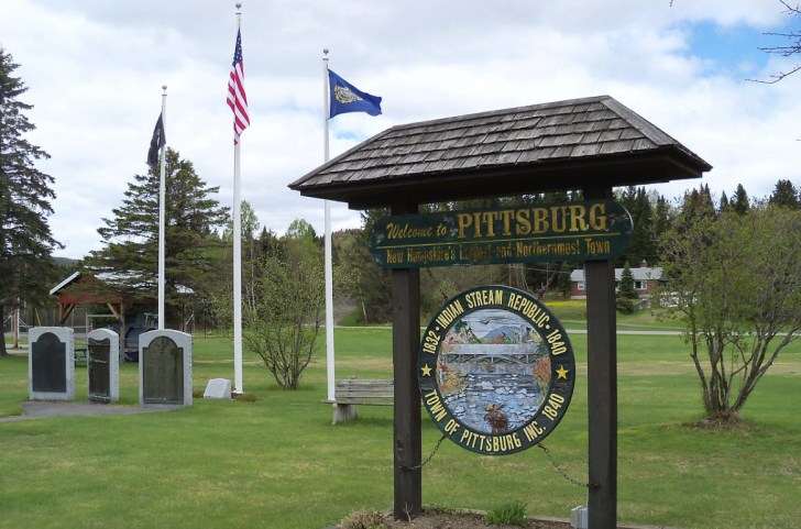
This isn’t Pittsburgh, Pennsylvania.
This isn’t Pittsburg, Kansas.
This is Pittsburg, New Hampshire, the largest city by land mass east of the Mississippi River and a border town with Canada at Chartierville, Quebec.
Pittsburg is part of the Great North Woods of New Hampshire, but it’s even farther north than even the scenic drive.
With its picturesque landscape, Pittsburg offers outdoor enthusiasts a paradise of natural beauty and recreational opportunities, including the Connecticut Lakes, several state parks, and wildlife preserves.
You will likely be going here for one of three reasons:
- You want to get away from it all in the most literal way possible.
- You are driving to or from Canada.
- You have an odd desire to be outnumbered by bear and moose by a 10 to 1 margin (approx.).
The Great North Woods abuts Maine’s Rangeley Region, but it’s so remote you’d have to take an hour detour to find a paved road that leads into Maine.
Pittsburg is known as the “Snowmobiling Capital of New England,” offering an extensive trail network that connects to other parts of New Hampshire and neighboring states.
Just across the border in Canada, you can experience the gravity-defying “Magnetic Hill.”
The Great North Woods offers a space of peace, tranquility, and seclusion you can’t find in many states, on top of an international adventure.
Warnings & Dangers in Pittsburg

OVERALL RISK: LOW
There's a low overall risk here as far as crime goes, but wilderness risks are definitely at a medium level unless you're an expert outdoor adventurer.

TRANSPORT & TAXIS RISK: MEDIUM
You'll need your own car here. There's no public transportation. Calling a taxi or rideshare, even if one was available, would be hard since there's little mobile phone reception. Treat the paved and back roads as a medium risk, mostly due to weather damage and dangers.

PICKPOCKETS RISK: LOW
This is a low risk. You're much more likely to poorly pack a backpack and attract a bear than get pickpocketed.

NATURAL DISASTERS RISK: MEDIUM
Pittsburg experiences a diverse range of weather risks throughout the year. Winters can bring heavy snowfall and freezing temperatures, increasing the risk of winter storms and icy conditions. In the summer, severe thunderstorms are possible, with the potential for strong winds, hail, and occasional tornadoes. Hurricanes and nor'easters fuel the storm potential all year round. Hurricane season is from June through November, and nor'easters kick up anytime between October and May.

MUGGING RISK: LOW
This is a low risk. You will see a lot of people with guns here, but that's mostly for hunting and personal protection.

TERRORISM RISK: MEDIUM
There's a medium risk as challenges at the border can lead to smugglers or drug dealers getting into the country. Even something as innocuous as a stick in the road was found to be a signal for a drug drop-off point. Never carry anything across the border for another person, and always be wary of people on the side of the road in the wilderness near the border.

SCAMS RISK: LOW
There's a low risk here. The entire 300-square-mile city has just 800 residents, and while this is a tourist destination, it's only sought out by the most rugged adventures. You can read the Federal Trade Commission website for the most common scams in America.

WOMEN TRAVELERS RISK: LOW
As long as women know wilderness, weather, and wildlife safety, there's not any greater risk than for men. It can be uncomfortable to travel into such a remote area alone, and traveling with a group of at least three people is strongly recommended.

TAP WATER RISK: LOW
You can email the town at publicworks@pittsburg-nh.com for the latest water quality testing information. If you're staying in a cabin or at a campsite, as the manager for the latest water quality testing results. Don't drink water directly from the lakes. Check the New Hampshire Department of Environmental Quality for updates on how to filter lake water for safe consumption.
Safest Places to Visit in Pittsburg
You have several resources to find tourism information.
First, the Visit New Hampshire website has a section for the Great North Woods.
The Pittsburg town website has a section for “Exploring Pittsburg.”
The website NHGrand.com also explores Pittsburgh and nearby towns of the “Grand North.”
The center of Pittsburg isn’t one of those charming streets lined with businesses.
It’s more spread out with businesses along Route 3.
You can find a town green with a war memorial and a trading post across the street.
Most of the town’s core runs parallel to the Connecticut River until joins Lake Francis.
From there, the road twists north past the Connecticut Lakes (1, 2, and 3) before arriving at the border.
Once you pass First Connecticut Lake, you’ll be on a road nicknamed “Moose Alley.”
Get ready for moose sightings.
The town hall of Pittsburg is also a historical museum.
Hours are limited, but if the flag is flying out front, the museum is open.
You can call (603) 538-6697 to check hours as well.
Pittsburg Ridge Runners Clubhouse is the place to visit if you want to learn about the history of snowmobiling or get expert guidance for a ride.
Climbing Magalloway Mountain is one of the safest summits you can do.
The trail is a little tough, but it’s just 2.2 miles, and you’re at one of the highest points in the North Woods.
A fire tower at the top is usually open for hikers, offering an even higher view.
We recommend those who aren’t outdoor experts spend time on preserved land managed by a government entity for safety.
Lake Francis State Park is a popular four-season destination closer to the core of Pittsburg.
Washburn Family Forest is technically in Clarksville, but it’s right across the river from Pittsburg.
This is popular fishing, hunting, and snowmobiling location.
The Bog Bridge Trail starts at the highway but ventures into the woods to First Connecticut Lake.
The Connecticut Lakes Natural Area is more remote but does offer five peaks to explore and diverse terrain and ecosystems.
Use the New Hampshire State Parks website blog to find the best waterfalls in Pittsburg, which are especially active in late spring and early summer.
Just across the Canadian Border is Magnetic Hill.
It appears to be an uphill road, and a sign gives instructions in English and French on how to get your car to drive itself “up” the hill.
A little farther north is Centre d’interpretation de la mine d’or, a gold mine with numerous attractions and places to explore.
There’s a suspension bridge that takes guests to the old mine that was active from 1862 through 1960.
Places to Avoid in Pittsburg
You really need to know how to navigate using just maps and a compass here, as many trails aren’t maintained, and others can become overgrown or have downed trees.
All wilderness areas under the state park organization or federal protection have websites with weather, danger, and wildlife information.
Whenever possible, check in with a ranger.
Let people know your plans and when to expect you back.
Don’t try to “wing it” in the wilderness.
Too many people get lost looking for a waterfall or don’t know the sunset and weather forecast information enough to make smart hiking decisions.
You can buy a Hike Safe Card from the New Hampshire Department of Fish & Game to cover the costs of a rescue.
Otherwise, you could foot the bill for your own rescue.
The card does not provide protection against reckless behavior and ill-prepared adventures.
Safety Tips for Traveling to Pittsburg
- The Pittsburg Police Department also covers Clarksville. The main phone number is 603.538.7003. You can also email the police chief at rdube@pittsburg-nh.com if you have specific safety questions.
- Anglers and hunters need a license, but the hunting license will require safety training. Download the New Hampshire Fish & Game app to get all the information you need to plan for these activities.
- If you see someone illegally poaching in the wilderness, don’t confront them. Instead, call the anonymous poaching hotline at 1-800-344-4262.
- Study information from New Hampshire’s Environmental Services Department (NHESD) about blue-green algae. These blooms are naturally occurring in lakes during warm weather, but they are also toxic. Humans can get sick from it, but those traveling with dogs should know how just a little bit of algae exposure can kill a dog within hours.
- Check the lake monitoring section of the NHESD to see if algae or other risks are present in the water. Some contaminants can’t be filtered or boiled out of water.
- While driving Moose Alley is a great way to see moose, it’s also dangerous for you and the moose. Since moose are so tall, their eyes are too tall to reflect in the headlights of a car. The animals are especially active at dawn and dusk, leading to nearly 100 moose vs. car accidents per year over the past five years. FWIW – moose always have the right of way.
- Before you consider ice fishing, ice skating, or driving a car on a frozen lake, you should know how to test the thickness. It might be very cold while you’re visiting, but the weather fluctuations of the weeks before could mean the ice isn’t as strong as it looks.
- Everything you carry into the wilderness, campsites, and even the populated parts of town should be bear-proof. Carry bear spray on your hip. Use bear-proof containers. Don’t even throw a candy wrapper on the side of a trail.
- You are expected to “Leave No Trace” in the wilderness, and that means all trash you accumulate must come back with you—even human waste. Plan ahead for this to have the right bags and seals on bags to prevent leaks and awful odors.
- You can wear bug spray to ward off the mosquitoes and some bugs, but the bitting horse flies and other insects won’t flinch at bug spray. Wearing netting or long-sleeved shirts and long pants tucked into socks is the only way to avoid the wall of bugs active during summer. For more motivation, you should know that biting flies don’t just sting like mosquitoes. They use scissor-like appendages to cut into your skin, leaving a welt and causing pain similar to a bee sting.
So... How Safe Is Pittsburg Really?
You can count all the crimes in Pittsburg from 2021 on one hand.
That’s how safe it is, at least from criminal activity.
Even with just three thefts in 2021, two of those were still car accessory thefts, reminding you that no place is too safe to leave your car unlocked.
Quite frankly, you should be more concerned about a bear tearing up the inside of an unlocked car than a thief, but whatever motivates you to keep up with safety precautions works for me!
This is truly rugged, wild, untouched wilderness.
Those hungry to explore the summer trails could find themselves eaten up by biting giant flies and mosquitoes while ticks dig into every spot of exposed skin.
Winter visitors could be snowmobiling their way through a storm with accumulation taller than the average human.
If that above statement makes you roll your eyes, then this is the place for you.
If you’re still wondering about giant biting flies, maybe consider one of the towns closer to The Lakes region.
About 20 miles south of the border, there’s nothing but a wooded highway.
You won’t find services or be able to call for help easily.
Pittsburg is truly an outdoor paradise in a state filled with outdoor heavens.
It’s also a place that can scare the bejeezus out of you if you’re an “indoor” person.
How Does Pittsburg Compare?
| City | Safety Index |
|---|---|
| 70 | |
| 82 | |
| 78 | |
| 76 | |
| 81 | |
| 79 | |
| 63 | |
| 83 | |
| 60 | |
| 82 | |
| 70 | |
| 82 | |
| 64 |
Useful Information

Visas
To get into the United States from Canada, you'll need a passport and a visa or visa waiver. For those entering Canada, you should check with Canada Border Services Agency. It's important to know that Canada has some strict rules, like those with a DUI will have a hard time getting approved for entry without going through the proper channels. Even then, it's not guaranteed.

Currency
There might be a handful of places that accept the Canadian Dollar, but by and large, you should plan to spend the United States currency (USD). Carry cash with you, as some businesses might be cash-only. Try to pay as much as possible with a credit card to get the best fraud protection.

Weather
When packing for a trip to Pittsburg, NH, consider the outdoor activities and weather. Bring layers, including a waterproof jacket and sturdy shoes for hiking or snowmobiling. Pack fishing gear if interested, along with camping essentials if planning to camp. Don't forget insect repellent and sunscreen for added protection.

Airports
The closest airport to Pittsburg, NH, is the Eastern Slopes Regional Airport (IZG), 63 miles away in Fryeburg, Maine. You would have to book a charter plan to get there. Burlington International Airport (BTV) in Burlington, Vermont, is about 122 miles southwest of Pittsburg, and Manchester-Boston Regional Airport (MHT) in Manchester, New Hampshire, is approximately 156 miles southeast of Pittsburg. Montréal-Pierre Elliott Trudeau International Airport (YUL) is the closest Canadian commercial airport, about 225 miles away.

Travel Insurance
Travel insurance that covers wilderness adventures is strongly recommended. Rescues can take a long time, and getting to a hospital that treats injuries could take a while. It might even involve a helicopter ride ($$$$). Rental car insurance should be comprehensive to cover driving dangers on rural roads.
Pittsburg Weather Averages (Temperatures)
Average High/Low Temperature
| Temperature / Month | Jan | Feb | Mar | Apr | May | Jun | Jul | Aug | Sep | Oct | Nov | Dec |
|---|---|---|---|---|---|---|---|---|---|---|---|---|
| High °C |
-6 | -4 | 1 | 8 | 17 | 21 | 24 | 23 | 19 | 12 | 4 | -2 |
| Low °C |
-18 | -18 | -12 | -3 | 3 | 9 | 12 | 11 | 6 | 1 | -5 | -13 |
| High °F |
21 | 25 | 34 | 46 | 63 | 70 | 75 | 73 | 66 | 54 | 39 | 28 |
| Low °F |
-0 | -0 | 10 | 27 | 37 | 48 | 54 | 52 | 43 | 34 | 23 | 9 |
New Hampshire - Safety by City
| City | Safety Index |
|---|---|
| 79 | |
| 83 | |
| 77 | |
| 68 | |
| 81 | |
| 76 | |
| 74 | |
| 78 | |
| 78 | |
| 79 | |
| 78 | |
| 76 | |
| 73 | |
| 73 | |
| 70 | |
| 82 | |
| 79 | |
| 82 |


I recently visited Pittsburg, Kansas, and felt safe throughout my stay. The article’s mention of a low overall crime risk aligns with my experience; it’s a welcoming town with a strong sense of community.
It’s good to know that Pittsburg has a low overall risk rating. The emphasis on wilderness risks is helpful for outdoor enthusiasts like me to plan accordingly.
Pittsburg’s commitment to safety is commendable. The city’s initiatives, like the well-monitored ‘Exchange Zone,’ reflect a proactive approach to community well-being.
Having traveled through Pittsburg, I found the city to be welcoming and attentive to visitors’ safety. The local authorities seem dedicated to maintaining a secure environment.
Stumbling into Pittsburg felt like stepping into a hidden gem, where the quiet beauty of nature surrounded me and I finally found the peace I didn’t know I was searching for.
Did you really mean there are more bears and moose than people up there? That’s wild, it sounds like a totally unique experience!
Guess I’ll just add “outnumbered by bears” to my bucket list of unique travel experiences, because who wouldn’t want that?
Tried the snowmobile trails and honestly felt outnumbered by moose, saw maybe ten and it was kinda unnerving.
Getting stuck behind a moose on those snowy trails was way more nerve-wracking than I expected.
So how’s the whole being outnumbered by bears thing really work out when you’re just trying to enjoy a peaceful snowmobile ride?
Spent a weekend snowmobiling there last winter and the silence of the snow-covered woods mixed with the thrill of spotting a moose nearby made it feel like stepping into another world entirely.